June 2013
24.6.2013 Section 2 ( ½ )
24/06/13 23:37
Time and weather prevented me from starting the second leg of the LL ( London Loop ) earlier.
But today is the day, Day 2 to be precise. Why only ½ will be explained later.
Naturally I started where I finished the last time: Bexley Railway Station. Just behind the station one reaches the Bexley meadows with the River Cray and it's cricket club.
Only the "master of the lawn" was around repairing, as I assume, the damage of Sundays match.
Across the plateau which seperates the Bexley from the North Cray meadows one reaches the the River Cray again. The path follows the river at it's bank and after a short walk the Five Arch Bridge which was leading at one point in time to Pike Place ( now Foots Cray Place ) which belonged for some time Sir Francis Walsingham, Secretary of State to Queen Elizabeth I.
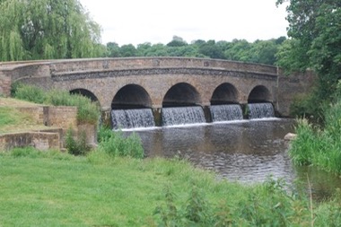
The Foots Cray Meadows are landscaped by "Capability" Brown who was commissioned in 1781 to carry out the work.
The picture page will give you a little impression of this jewel so close to my home. Having reached this point I started getting really trouble walking.
I'll just say: right shoes, wrong socks.
Two nice blisters made walking not very pleasurable anymore.
But being in the middle of the Cray meadows I had to get on.
Walking along the river one reaches the end of the meadows with a little bridge having the interesting name of "Pennyfarthing Footbridge" having crossed the bridge one can see the spire of "All Saint Foots Cray". Along Rectory Lane with the old Harenc School Building with it's clock tower one reaches the "centre" of Foots Cray village where I decided to call it a day and wait for the 51 bus to get me home.
The blisters made walking impossible !
To be continued.
But today is the day, Day 2 to be precise. Why only ½ will be explained later.
Naturally I started where I finished the last time: Bexley Railway Station. Just behind the station one reaches the Bexley meadows with the River Cray and it's cricket club.
Only the "master of the lawn" was around repairing, as I assume, the damage of Sundays match.
Across the plateau which seperates the Bexley from the North Cray meadows one reaches the the River Cray again. The path follows the river at it's bank and after a short walk the Five Arch Bridge which was leading at one point in time to Pike Place ( now Foots Cray Place ) which belonged for some time Sir Francis Walsingham, Secretary of State to Queen Elizabeth I.
The Foots Cray Meadows are landscaped by "Capability" Brown who was commissioned in 1781 to carry out the work.
The picture page will give you a little impression of this jewel so close to my home. Having reached this point I started getting really trouble walking.
I'll just say: right shoes, wrong socks.
Two nice blisters made walking not very pleasurable anymore.
But being in the middle of the Cray meadows I had to get on.
Walking along the river one reaches the end of the meadows with a little bridge having the interesting name of "Pennyfarthing Footbridge" having crossed the bridge one can see the spire of "All Saint Foots Cray". Along Rectory Lane with the old Harenc School Building with it's clock tower one reaches the "centre" of Foots Cray village where I decided to call it a day and wait for the 51 bus to get me home.
The blisters made walking impossible !
To be continued.
Start Day ( 8.6.2013 )
08/06/13 18:45
Weather forecast for today is great. Overcast in the morning followed by blue sky and sunshine and temperatures around 20 C.
Great,
I can finally start the project of walking around London. Today it's section 1: Erith - Bexley. Almost home turf, at least the final part.
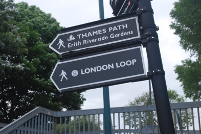
The 9:40 departure from Sidcup station gets me to Erith. A short walk to the official unofficial starting point of the walk, situated directly at the Thames.
Erith is a very industrial town at the Thames estuary, not very charming but as soon as one has left the town and reaches the marshland it changes completely. Along the estuary, on top of the flood defenses it is a very pleasant walk through the wind-swept marshland with the QE2 bridge of the Dartford Crossing on the horizon.
One can still see old WW2 air defense bunkers surrounded with ponies grazing. Leaving the Thames behind one then follows the River Darent through the Crayford Marshes to the point where the River C ray flows into the Darent.
After a while one reaches Crayford with its nice town centre. Leaving the town along the River Cray one reaches a vast open space: Hall Place.
Build around 1540 by a former Lord Mayor of London it belongs now the the London Borough of Bexley. Both house and gardens are open the public and a nice restaurant directly of the river Cray forced me to have some tea and scones.
Refreshed the walk continued through Churchfield Wood and emerged then at St.Mary's Church Bexley with it's funny shingled spire. Through the busy Bexley High Street passing the big and weatherboarded mill on the Cray to reach Bexley station, the final point of this section.
8 ¾ miles are done, 143 ¼ to go
For some pictures of this section: click here
Great,
I can finally start the project of walking around London. Today it's section 1: Erith - Bexley. Almost home turf, at least the final part.
The 9:40 departure from Sidcup station gets me to Erith. A short walk to the official unofficial starting point of the walk, situated directly at the Thames.
Erith is a very industrial town at the Thames estuary, not very charming but as soon as one has left the town and reaches the marshland it changes completely. Along the estuary, on top of the flood defenses it is a very pleasant walk through the wind-swept marshland with the QE2 bridge of the Dartford Crossing on the horizon.
One can still see old WW2 air defense bunkers surrounded with ponies grazing. Leaving the Thames behind one then follows the River Darent through the Crayford Marshes to the point where the River C ray flows into the Darent.
After a while one reaches Crayford with its nice town centre. Leaving the town along the River Cray one reaches a vast open space: Hall Place.
Build around 1540 by a former Lord Mayor of London it belongs now the the London Borough of Bexley. Both house and gardens are open the public and a nice restaurant directly of the river Cray forced me to have some tea and scones.
Refreshed the walk continued through Churchfield Wood and emerged then at St.Mary's Church Bexley with it's funny shingled spire. Through the busy Bexley High Street passing the big and weatherboarded mill on the Cray to reach Bexley station, the final point of this section.
8 ¾ miles are done, 143 ¼ to go
For some pictures of this section: click here